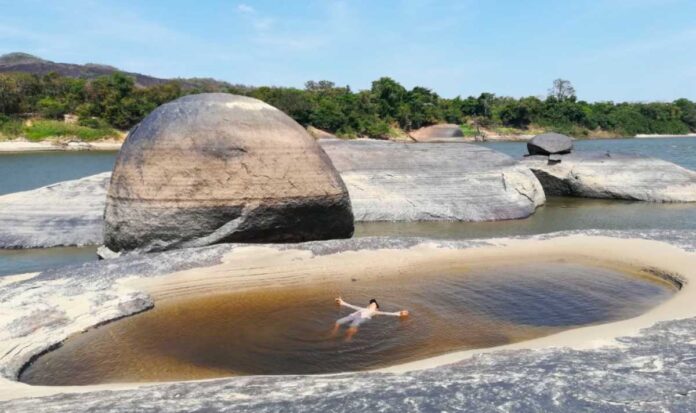
The island of Saint Helena, with an area of around 350 hectares, shows rocky outcrops characteristic of the Guiana shield. The only access to this place is by river transport along the Orinoco River.
It is commonly known as the jewel of the Orinoco by many of its visitors. At this site, tourists can explore five trails that traverse diverse landscapes, including tropical dry forest, floodplain forest, beaches, savannas, and rock formations. The island becomes a strategic point for the sport fishing and the installation of camps. It is surrounded by the Orinoco, Bita and Meta rivers, as well as the Dagua and Juriepe channels, where it is possible to capture and release specimens of emblematic sport fishing fish, such as the Pavón, the Payara and La Sardinata, in addition to the Morocoto, the Cachama and several species of Catfish.
(Read Also: Nimajay Natural Reserve or Refuge of Puerto Carreño)
In addition to fishing, visitors can enjoy various entertainment activities, such as boat rides on the river, bathing in beautiful golden sand beaches, natural pools and contemplation of the impressive landscapes offered by the Orinoco basin, the Guayanes Shield. , the abundant vegetation and the majesty of the sunrises and sunsets of the Llanos.
Where is Saint Helena Island located?
The island of Santa Elena is located 22 km in a straight line from the urban area of Puerto Carreño, capital of the Vichada department. Its only access is by water, so it is best to access it accompanied by expert tour guides in the area.


